
Hello weirdo!

Random
Misi Gunung
List of mountains (DONE)
Trans Full C-Curve
#40mountainsin2018
#30mountainsin2017
#20mountainsin2016
#10mountainsinJapan
#10mountainsin2014
Links
Akmal | Ajiq
Julian.B | Kimmo.S
Sunday, September 24, 2017, 10:22 AM
Done and dusted!
Finally completed the #10mountainsinJapan post after 2 years. haha. Hopefully it gives you some ideas and insights on how it would be like to hike in Japan. I will probably make a Malay version of my journey in another website (still working on it, which I don't know how long will it takes. haha). #survivingJapan trip taught me a lot. It left me speechless and turned me into a story-teller. I wish to go further and discover more, especially on mountains and culture parts.
So if you have any questions or inquiries regarding #10mountainsinJapan, feel free to ask, hit up the comment button. I don't eat people :)
Misadventure in Indonesia coming up next!
Labels: 10mountainsinjapan, itraveltohike, japan, misigunung
Friday, September 22, 2017, 5:26 PM
10. Mount Fuji
They said "save the best for the last".

Mount Fuji (富士山) or Fuji-yama or Fuji-san is the
tallest (3,776m) and the most famous mountain in Japan. It is an icon, a proud
of Japanese people. Stands on the border between Yamanashi and Shizouka
prefecture, Fuji-san is also known as a sacred mountain, a part of Three Holy
Mountains of Japan and listed as one of the ultra-prominent peaks (with
topographic prominence greater than 1,500 metres).


The official climbing season for Mount Fuji only open on
summer which starts from early July to mid September. On other season, the
mountain is capped with snow and not many mountain huts are operating/open, so
hikers especially beginner are not advised to hike.
Mount Fuji has 4 different trails to the peak :-
- Yoshida Trail (Fuji Subaru Line)
- Subashiri Trail
- Gotemba Trail
- Fujinomiya Trail

I was supposed to hike with the Malaysian team (refer to my Minami Alps post), but due to bad weather (thypoon to be exact), I pulled out from the trip last minute and planned my own trip with another friend of mine who did not manage to summit the other day.
We chose to use the easiest and the most popular trail, Yoshida trail. So we decided to take the highway bus straight from Shinjuku
to Fuji 5th station, but unfortunately it was sold out a day before (so fast!).
But worry not, we found other alternative, by train.
 |
| Nah... not this. This is a luxury one. |
 |
| This one. |
Nakano Station – Shinjuku Station - Otsuki (JR Limited Express train (Azusa or Kaiji)) – Kawaguchiko Station (Fujikyuko Railway) – Fuji 5th Station (bus in front Kawaguchiko Station)
We reached 5th Station by 5.54pm (Japan time) when the sun
just about to set. We took some time to enjoy the scenery, packed our bags and
used the toilet (it’s free here at 5th station). We started hiking around
6pm-ish. There is no permit fee for Mount Fuji, but there is conservation
donation about 1000yen (optional). I donated and received few pamphlets on
Fuji, a batch and wifi password (yes! there is wifi at Mount Fuji, all the way
from 5th station to the peak).


The weather was nice but cold. As we hiked further, it got colder and darker. And to be honest, cold weather is my weakness. We
stopped at each station, catching breath and trying to collect thoughts
(because coldness made us lost our mind).
I hit my limit at 7th Station. I could not comprehend the coldness (emergency blanket failed to keep me warm) and decided to sleep in the hut to recover. Afraid that if I proceed I might get hypothermia. The weather was no joke, freaking cold. It was 9°C at that night and they said it might drop to zero in the morning. My friend, however, continued the hike as he really wanted to witness the sunrise from the peak. I bid him goodbye and went to sleep right away.
I woke up in the morning feeling all fresh (the mattress was very comfortable. of course la best, I paid 5500yen for it). I went out and saw many hikers outside and on the trail. The scenery and sunrise were amazing. I bet it looks spectacular up there, on the peak. But never mind, there is always next time.
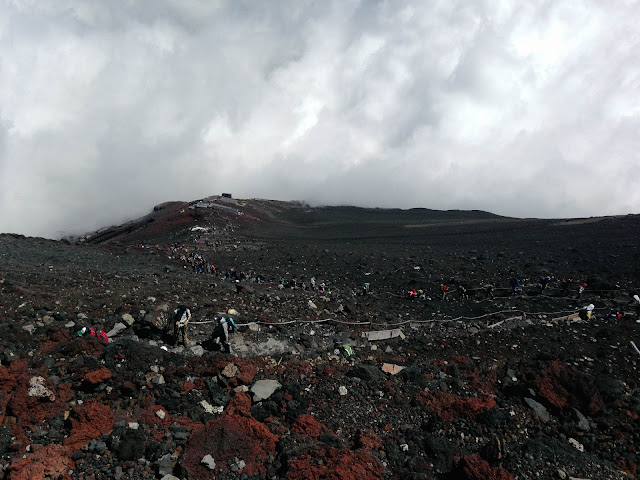
I continued my hike around 6AM-ish. It was less cold, but the trail was packed with hikers and there were long queue until the peak.
I stopped at 8.5th station for toilet and stupidly left my hat there and I proceeded the journey while cursing at my stupidity along the way. Haha.
I woke up in the morning feeling all fresh (the mattress was very comfortable. of course la best, I paid 5500yen for it). I went out and saw many hikers outside and on the trail. The scenery and sunrise were amazing. I bet it looks spectacular up there, on the peak. But never mind, there is always next time.
I continued my hike around 6AM-ish. It was less cold, but the trail was packed with hikers and there were long queue until the peak.

I stopped at 8.5th station for toilet and stupidly left my hat there and I proceeded the journey while cursing at my stupidity along the way. Haha.

 |
| Where I stupidly left my hat. |


I reached the top around 11AM-ish (Japan time).
 |
| When you asked other people to take your picture but you cannot complain. Haha. |
There were temple and few shops on top. Also, an excavator.


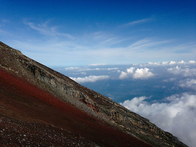
I walked around the crater rim and saw a long queue of hikers waiting for their turn to take picture at the highest point of Mount Fuji.

After few minutes of walking, I decided to descend as I had bus to catch! I hurriedly went down. The descend trail has many zig-zags (about 23-24) and that took me about 3 hours to reach the trail head. Thank God, I got there on time and took the last bus to Kawaguchiko train station.


While I was on the bus I met a Germany trail runner who is currently staying in Japan for work and has been to Mount Fuji for 49th times the moment we spoke. He said Mount Fuji is a training ground for many trail runners, including him. Our conversation was mostly covered on mountains. He told me about UTMF while I told him about mountains in Malaysia and why he should sign up for Kinabalu Climbathon.
We parted ways once we reached the train station. It was nice to speak to another stranger in another country (actually it was more to feeling grateful that I finally met someone who can speak English.haha). I went to Tokyo with a happy feeling knowing that I completed my #10mountainsinJapan mission successfully. Alhamdulillah. Yeay!

Labels: 10mountainsinjapan, fuji, itraveltohike, japan, misi2015, misigunung
Wednesday, September 20, 2017, 4:30 PM
6. Mount Takao, 7. Mount Kobotoke Shiroyama, 8. Mount Kagenobu & 9. Mount Jinba, Hachioji, Tokyo
Mount Takao is one of the nearest mountains
you can hike if you are in Tokyo. Located at Hachioji city, this mountain is a part of Meiji no mori Takao Quasi-National Park and it takes only an
hour to reach the trailhead by public transportation. You can choose either to hike Takao alone or do
the traverse hike from Mount Takao – Mount Jinba. Being me, it’s always the latter.
Traverse hike Mount Takao - Jinba consists of 4 mountains :-
Traverse hike Mount Takao - Jinba consists of 4 mountains :-
- Mount Takao (599m)
- Mount Kobotake Shiroyama (670m)
- Mount Kagenobu (727m)
- Mount Jinba (857m)

Nakano (Tokyo) – Shinjuku – Takaosanguchi – Takaosan
So here’s our train journey from Nakano (where we were staying) to Takao
trailhead. From Nakano (Tokyo) train station, I took JR Chuo Line Rapid (to
Tokyo). I stopped at Shinjuku and changed to Keio Takao Line Limited Express to
Takaosanguchi. From here, we walked for few minutes to the trailhead. If you
are not sure where to go once you get off the train, just ask the ticket
counter. Since Takao-san is pretty famous among Japanese, they can show you the
way.
There are 6 different trails to choose.
- Omotesando Trail
- Kasumidai Loop Trail
- Katsura Woods Trail
- Suspension Bridge Trailk
- Mt. Takao Peak Loop Trail
- Biwa Waterfall Trail


I chose Trail No. 6 – The Biwa Waterfall Trail. The trail,
like its name, greeted us with the magnificent scenery of Biwa Waterfall and Iwayadaishi
temple. The 3.3km distance trail took about 90 minutes to reach the peak.


Since we hiked on weekdays, they weren’t many people around.
But on weekdays, this mountains are pretty much packed with hikers. After few
minutes rest, we proceeded our journey to Mount Kobotoke Shiroyama. As I was
not familiar with the trail, I used offline map that I downloaded from Yamap
App (or you can get the physical map at Takao Visitor Center). Most of the
signanges are in Japanese, so if you cannot understand Japanese, it is better
to get your phone equipped with translation apps.


About one hour trekking from Mount Takao peak, we reached
Mount Kobotoke Shiroyama. During weekend, this place is happening as there are
mountain huts and small shops selling food and beverage. But during our hike, it
was like a dead town, no one was around and we were the only hikers. Haha.


We hiked another half an hour and found ourselves this
pretty view of Lake Sagami near the peak of Mount Kagenobu. We were quite devastated earlier because we could
not see any view from Mount Takao peak as it was foggy. But once we saw Lake
Sagami, we felt relief, happy and motivated to continue our journey to the last
peak, Mount Jinba. Not to mention that we also almost ran out of water. GG.


We finally reached the last peak at 2pm. To our delight, we
saw one small shop opened, perhaps the only one opened on that day after 20km
hiking journey! We enjoyed the scenery and short conversation with the shop
owner and descended right after as we had bus to catch! Afraid that if we
spent more time we might missed the bus. But thank God we reached the bus stop
on time.


Mount Takao is good for beginner, but if you wish to try the traverse trail make sure you bring enough water, food and a map. The trail is also famous among trail runners and many of them make it as their training ground (perhaps due to its never-ending stairs, which I think brilliant to add into the routine).
Summary :
Trailhead no. 6 – Mount Takao (1 hour 30 minutes) – Mount
Kobotoke Shiroyama (1 hour) – Mount Kagenobu (30 minutes) – Mount Jinba (2
hours) – Jinba Kogen Shita bus stop (3 hours)
Sources : Trans takao-jinba , takao trails ,
p/s : have a chat with the shop owner at Mount Jinba, he can speak English!
p/s : have a chat with the shop owner at Mount Jinba, he can speak English!
Labels: 10mountainsinjapan, itraveltohike, japan, jinba, kagenobu, shiroyama, takao
Thursday, September 14, 2017, 6:13 PM
3. Mount Kita (北岳), 4. Mount Nakashirane (中白峰山) & 5. Mount Aino (間ノ岳), Minami Alps, Yamanashi/Shizouka
Mount Kita (3,193m/10,476ft) is the second tallest mountain after Fuji-san, Mount Aino is the 4th tallest in Japan, while Mount Nakashirane (3,055m /) is located between these two giants. And all of them are a part of Akaishi Mountains−Southern Alps, in Minami Alps (南アルプス Minami-Arupusu) National Park, Shizouka prefecture. Going here isn't hard as it is can easily be accessed by public transport.

Shinjuku (train) - Kofu (train) - Hirogawara trailhead (bus schedule)
We arrived at Hirogawara trailhead around noon, but we could not start the trekking yet as we were still waiting for another two team members to arrive. They missed their flight a day before. So we decided to stay for a night at Hirogawara-sanso (mountain hut).


Even though there's no permit issued for mountains in Japan, hikers still need to pay for facilities (if they ever use one). For instance :-
1. Toilet (100yen)
2. Campsite (500yen)
3. Water (100yen per liter)
4. Charging gadget (100yen)
5. Mountain hut (price range is usually from 4000 - 6000yen)
We started our journey to Kitadake the next day in the morning. The trail and signage were pretty well-marked and well-maintained. Clear trail all the way, But still, I used Yamap GPS as precaution. It took about 4 hours 30 minutes trekking to another mountain hut, Shiraneoikekoya (mountain hut).


And then we proceed to Kitadake Katanokoya (mountain hut) and stayed overnight. 6 people (including me) managed to reach the mountain hut before sunset. While the others came around 9-10 PM. The organizer and the other guy (line-up) had to go back to rescue them.


We woke up around 2AM in the morning for summit attack. It was very cold in mountain area despite the summer season. We reached the peak of Kitadake after 1 hours and 30 minutes of trekking. We stopped for awhile to regroup with other team members before continued our journey to Mount Nakashirane. After about 2 hours trekking, we reached Kitadakesanso.

We had some issues here where some of the members did not want to proceed to the other two mountains as they did not have enough rest because they reached Kitadake Katanokoya pretty late last night. Besides, we had to speed up our pace a little bit to catch time. So, few people decided to stay at Kitadakesanso (as they were not confident enough that they can keep up with our pace) while the rest continued the journey.
It took about 1 hour to reach to the second peak, Mount Nakashirane. We did not stay for long as we were quite behind the schedule. After few minutes of rest, we proceed to Ainodake, which took us only about 1 hour to get there. Thank goodness the weather was nice towards us that day. Despite the challenging trail, we were quite lucky to be given a chance to experience sunrise and sea of clouds along the way.


Without wasting our time, we descended as fast as we could to Kitadake Katanoya which took us about 6 hours. We packed our stuff, then headed down to Hirogawarasanso, but then due to certain issues (again), we could not make it to the trail-head on that day. We had to spend another night at Shiraneoikekoya. And this is when I suddenly became their runner/shooter to book rooms at the mountain hut. And thank goodness I was quite fit to run all the way down as fast as I could before sunset. I somehow managed to get there in time and booked it for all of us despite the language barrier (thank god for sign/body language).


This time, I had ample time to wander around, observe and use the facilities in mountain hut. What impressed me the most is, they have heated room for wet hiking clothes, stuff. So we can dry it right away while doing other things. And it's free. But this room, however, have time limit. They will make an announcement for hikers to pick up their stuff before they close the room, which is pretty convenient.


In most of mountain huts, they provide weather forecast because the Japanese are particular when it comes to this. And their forecast is pretty accurate too. Another thing foreign hikers should take note is noise. Usually the guests in any guesthouses or mountain huts are advised to not make noise after 9 or 10PM. It is Japanese culture to sleep and rise early. So make sure you respect and follow their rules.
We continued our journey to Hirogawara-sanso (trailhead) the next morning. We also spared some time to visit their Information Center while waiting for the bus. I managed to get the mountains' stamp, took some pamphlet and bought souvenirs.


Bidding goodbye to Minami Alps was probably the saddest thing I had to do because I love these mountains so much. The view, the trail, the surrounding, the people, are not something one can easily forget. I will definitely come again to enjoy the whole view of this mountain range.

So this is basically summary of our hiking journey, and this is only the ascent part because we used the same trail for descend, so it was pretty much the same.
Shinjuku (train) - Kofu (train) - Hirogawara-sanso (trailhead) - Kitadake Katanokoya - Mount Kita (Kitadake) - Kitadake-sanso - Mount Nakashirane (Nakashiranesan) - Mount Aino (Ainodake)
p/s : If you ever want to organize a hiking trip, make sure it is properly plan and you have enough crews to cater the needs of participants. Your participants are not your crew and if you gain income from the trip, the trip is definitely not trip 'kawan-kawan'. Don't take people for granted and don't simple crush the trust you have earned up until now.
Labels: 10mountainsinjapan, itraveltohike, japan, minami, misi2015